sQuiddio
Sailing Points of Interest
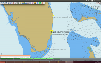
Find thousands of sailing Points of Interest right in your OpenCPN chart
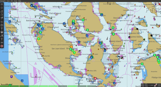
The sQuiddio plugin makes its global user-sourced and user-maintained repository of sailing Points of Interest available as waypoints in OpenCPN through a plugin. Typical POIs include:
-
marinas
-
anchorages
-
yacht clubs
-
docks
-
fuel stations
-
weather buoys
-
…and many others
Click on each POI’s icon on the chart to access basic information about the POI, such as a marina’s average user rating, address and phone number. Obtain additional information, see photos and user reviews by following the link to the POI page on sQuiddio.
Use the sQuidd.io plugin to plan your next cruise with the most up-to-date user-sourced information available.
Links
-
Website: sQuiddio.io
-
Source: Github Repository
-
Maintenance Source: https://github.com/rgleason/squiddio_pi
-
Release: Github Release
-
Download: Website Download
-
Forum: sQuiddio CF Thread
Installing the plugin
sQuiddio is available as a managed plugin. The OpenCPN Manual has general information in Plugin Download, Install and Enable for installing this plugin. This is the preferred way.
In OpenCPN, go to the Options → Plugins and download, install and enable the sQuiddio plugin (no settings are required).
-
First "Update" the master plugins catalog.
-
Select the sQuiddio entry and "Install" the plugin.
-
In the list of installed plugins "Enable" the sQuiddio plugin.
-
After successful installation, the plugin should be available in the plugins tab of your OpenCPN options dialog box.
Getting started:
-
To view POIs in a sector*:
-
Right-click on the area of the chart for which you want to view available POIs.
-
Select sQuiddio: Download (Update) local Points of Interest from the contextual menu (right click on the chart to launch the contextual menu).
-
For a touch device (e.g.Android), a right-click action is generated by a so-called “long touch”. Touch and hold the screen point until a context menu appears. Select the desired action.
-
Note: Not all phones generate an application context menu by touching the device “menu” button. Depends on the Android version and device mfg. The general method is “long touch” on the chart canvas. Should work on all devices.
-
-
a Sector is defined as an area of 5×5 degrees of lat/lon
Use of the plugin is free of charge. (Free registration is required for certain functions).
Features
Share your seafaring knowledge with others
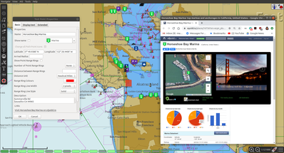
By following the link in the waypoint properties dialog, users can access information, images and user comments on the POI’s web site. Registered sQuidd.io users can post comments about the POI, as well as rate the POI on attributes such as beauty, service and quality of wi-fi access (where applicable).
View Weather Buoy and Ship Reports right on your chart
(version 1.3 or greater)
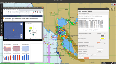
sQuiddio provides wind and wave reports obtained from the US National Data Buoy Center (NDBC) database updated on an hourly basis as POIs on your OpenCPN chart.
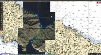
One-click download of Satellite Maps for any Point of Interest
(version 1.3 or greater)
Enhance your charts with the visual cruise-planning benefits afforded by satellite images. View detailed satellite maps of marinas or anchorages.
Follow your cruising friends on your OpenCPN Chart
(version 0.4 or greater)
Share your position, SOG and COG with boats in your sQuiddio follow list , and display their current position and heading on your OpenCPN charts
Using the plugin
Viewing Points of Interest:
-
In OpenCPN, go to the Options → Plugins and enable the sQuiddio plugin (no settings are required).
-
To view POIs in an area:
-
Right-click on the area of the chart for which you want to view available POIs.
-
Select sQuiddio: Download local Points of interest from the contextual menu. (if you have previously downloaded POIs for this area, the option will be named sQuiddio: Update local Points of interest
-
-
To view additional information about the POI, and a link to the sQuiddio POI page, right click on POI’s waypoint, and select Properties.
-
The waypoint dialog box includes a link to the Destination page on sQuidd.io. If you have an Internet connection, click the link and your browser should soon display the Destination’s page on sQuidd.io.
-
-
You can hide all POIs for an area from the charts by right-clicking on the chart and selecting sQuiddio: Hide local Points of Interest from the contextual menu. You can make the destinations visible again (without downloading them anew) by selecting the Show sQuiddio destinations.
-
You can also select the types of POI to show or hide: click on the sQuiddio icon in the toolbar, then the View tab, and select the types of POIs you want to display on the chart
POIs as OpenCPN Waypoints or OCPN Draw Texpoints
In earlier versions of the plugin (< 0.7), POIs were represented on the chart as OpenCPN Waypoints (which wasn’t optimal, as Waypoints were not intended to be used as static POIs). The introduction of the OCPN Draw plugin has enabled POIs to be rendered alternatively as ODraw Text Points, which has a number of advantages (e.g. view POI information upon hovering the mouse, POIs cannot be mistakenly moved etc.) . If you have the ODraw Plugin installed, we strongly recommend you select this option by going to the settings dialog → POI Rendering and selecting ODraw Textpoint as an option.
Submitting a new POI
sQuiddio relies on users like you to grow its database of POIs and keep it relevant. To submit a new POI:
-
Position your cursor on the new POI’s exact location in the OpenCPN chart
-
Right-click and select sQuiddio: Report a POI at this location from the contextual menu. (Note: you must have a free user account to report new POI. Signup https://squidd.io/signup )
Viewing NDBC Buoy and Ship reports
To view the updated reports:
-
NDBC Buoys and Ships appear just like of any other POI on your charts. Just make sure that the options NDBC Buoy Report and/or NDBC Ship Report are checked in the View tab of the plugin settings.
-
Position your cursor on the Sector of the chart that you want to see the Buoy or Ship reports for and select sQuiddio: Download (Update) local Points of interest from the contestual menu.
-
To view the last 10 wind and wave reports for a buoy or ship, double-click on the POI icon to open the Waypoint (Text Point) Properties dialog, then select the Display Text
-
Important! these POIs are not automatically updated over time, so you must select the sQuiddio: Update local Points of interest item in the context menu to download the most recent wind and wave reports.
-
Note that NDBC coverage is mostly limited to United States waters, with some non-US (but currently few) other locations. We are currently looking into adding other organizations with similar services (e.g. Metoffice). Please contact "info@squidd.io" for ideas and suggestions
Downloading Google Maps for one or more POIs
To download Google maps for a set of POIs:
-
Zoom in/out in your viewport so that only the POI(s) for which you want to download maps are shown
-
Select sQuiddio: Download Satellite Images for POIs from the contextual menu. A separate map is downloaded for each POI and for each level of zoom specified in the Download tab of the plugin settings. The plugin follows the Google Maps zoom levels, the default values being 17 ( ideal for, e.g., seeing the layout of a marina ) and 15, useful when planning an approach to an anchorage or marina. You will be provided an estimate of the size of the compressed file to be downloaded, and asked to confirm the download.
-
The Chart Database will be automatically updated when the download is complete and the Google Maps will appear on your chart (Note: if you have created a Chart Group for your Google Maps, you may have to close out and relaunch OpenCPN in order for the maps to show)
-
To change the zoom levels of the Google Maps to be downloaded, as well as the directory where you want your maps saved (maps are saved as raster files in the KAP format), click on the sQuiddio plugin icon in the toolbar and go to the Download tab
-
You can also choose to download a Map to cover the entire viewport, in addition to the individual POI-specific maps. See the option Include Viewport Map in the Downloads tab
Follow your cruising friends on your OpenCPN Chart
If you are sailing with a group of other boats, chartering with a flottilla, participating in a regatta or simply want to follow your friends as they brave the unknown from the comfort of your home, you can use sQuidd.io’s Follow List feature to track the other boats' position, speed and heading on OpenCPN (as well as on the sQuiddio web site). The plug in will retrieve the latest log updates from your Follow List and send your own GPS position at regular intervals. The plugin provides a choice of various time intervals, from ten seconds to once a day.
Log sharing requires a free account on sQuidd.io. To activate the feature:
-
Create your Follow list on sQuidd.io
-
Log into sQuidd.io
-
Go to the Dashboard and click on the Update Follow List button in the You are Following section
-
-
In the Authentication tab of the sQuiddio plugin settings, enter your sQuiddio ID (the email address you used to sign up) and your API key. You can retrieve your API key online by:
-
Logging into sQuidd.io
-
Clicking on the Preferences link in the top bar of the sQuiddio web site
-
Selecting the Numbers and Keys tab
-
-
In the Log Sharing tab of your sQuiddio plugin settings, select the intervals at which you want to receive and send log updates. Once the credentials are entered correctly and at least one of the two time intervals is set (and an Internet connection is available), the sharing process starts and a progress bar will be shown with timestamps of the last send/receive events (if you find that the status bar gets in the way, you can minimize it by dragging it to the edges of the viewport).
About sQuidd.io
sQuidd.io is a service designed and developed by boaters for boaters. We love the sea and believe that the best way to enjoy and protect this wonderful gift of Mother Nature is to facilitate the sharing of information among boaters. This is why most of the content you find on our site is generated by other users. We encourage you to contribute your seafaring knowledge to sQuidd.io by creating Points of Interest, rating your favorite ones and by providing information and feedback. Thanks to users like you, sQuiddio has become the most complete, comprehensive and up-to date source of cruising information in the world.
FAQ About the Website
Are there Destination reviews, or just "star" ratings?
Most of the info on the destination page is user-editable by clicking on the green “edit” link. The edit page has a Google map which can be used to adjust the exact location of the destination, and three tabs, that allow you to specify some basic info about the destination (phone number, email address etc), write and intro paragraph, or add a number of keyword-value pairs that provide additional information. All this updates the Destination page once the edits are saved. User reviews are entered in the form of user comments in the Media Feed, at the bottom of the page.
Are there data fields for things like dockage or mooring rates, approach depths, VHF channel, available services, nearby facilities, fuel prices, etc?
Yes. That’s what the above keyword-value pairs are for. With this approach, you have an unlimited number of potential attributes to define the destination. Just type anything you wish, e.g. “Toll Free Number” as a keyword, then the enter the corresponding value. There is a type-ahead filler in the keyword field that shows commonly used keywords (e.g. Guest Berths for a Marina, or holding for an anchorage), but you can enter what you want. Again, all these are shown on the Destination page
Also, what’s with all the flikr photos and links?
Photos are one of the objects that can be posted to the Media Feed, in addition to comments and reviews, since they are a great way to provide a visual dimension to the destination page. Users can upload their photos. In absence of user-supplied photos, we have pre-populated the media feeds of many destinations with photos from the public domain or services like Panoramio (discontinued) or Flickr based on lat/lon coordinates. As users add their own, the new ones will replace the old ones There is also a mechanism to provide photos and comments through social media (see the link at the bottom)
More info in the website FAQ
FAQ Destinations POI, Share, Check in/out, Twitter & Instagram, Photos
FAQ Stay Connected Share position with friends on a follow list. Spot, Cell, GeoSMS, Satphone, email
FAQ OpenCPN Plugin, API, POI, add POI, Log Sharing, Position.